The GPS Map Camera App seamlessly blends camera functionality with GPS location tracking. With features like geotagging, GPS scanning, and GPS mapping, it empowers users to create a visual chronicle of their journeys. The app boasts a robust mapping system that allows users to visualize their photos on a GPS map. Beyond its camera capabilities, the app enables users to append GPS location data to existing photos. Users can effortlessly craft a photo map of their adventures and browse their photos based on location. The app is user-friendly and integrates seamlessly with GPS-enabled devices. Whether you're a professional photographer or an avid photo enthusiast, the GPS Map Camera App is an exceptional tool for enriching your photos with geolocation data.
The GPSMapCameraApp boasts six key advantages:
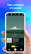
- Combines camera functionality with GPS location tracking: This app empowers users to capture photos while simultaneously tagging them with detailed geolocation data, providing a visual record of their travels.
- Offers a variety of options for capturing and tracking photos: Users can capture photos with a built-in GPS camera or add geotagging GPS location data to existing photos using the photo GPS location feature.
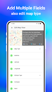
- Robust mapping system: The app incorporates a mapping system that allows users to effortlessly view their photos on a GPS map, making it easy to discern where each photo was taken in relation to their route.
- Date and timestamp formats: Users can select and add date and timestamp formats to their photos.
- Ability to customize photo names and save navigation: Users can save photos with custom names and benefit from live navigation for streamlined organization.
- Lightweight option available: The Lite version of the app offers many of the same features as the full version but occupies less space on the device.
Tags : Photography